
The Vice President of Nicaragua, Rosario Murillo has announced that on September 22nd 2023, construction will begin on another 31 kilometers of the “Carretera Costanera” (Pacific Coastal Highway).
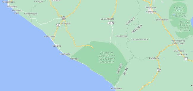
The route of this new section will start in Tupilapa in the Department of Carazo and move north connecting Playas; Hermosa, Huehuete, El Tamarindo, Casares, La Boquita, Masapa, Pochomil with Masachapa.
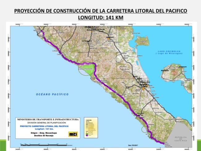
With this news, the Government of Nicaragua has now announced the start of work on four of the five “Tranches” or sections of the Pacific Coastal Road that were put out to bid.
Sections – Tranches
The tender notice for the construction of what is officially called the “Pacific Coastal Highway” identifies a total of 4 tranches/sections from the border with Costa Rica to Masachapa;
Tranche 1: El Naranjo (CR border) – Playa El Remanso, Municipality of San Juan del Sur (a section of 29.53 Kms)
Tranche 2: Playa El Remanso (SJdS) – San Juan del Sur – Empalme (road intersection) at El Coyol (Brito) (a section of 29.28 Kms)
Tranche 3: From the Empalme El Coyol (Brito) – Astillero (a section of 29.89 Kms)
Tranche 5: Tupilapa – Masachapa (a section of 30.79 Kms)
Note: The original plan always talked in terms of the Coastal Road starting n Masachapa and working its way towards the Costa Rica border at El Naranjo.
However, in recent years the project has been presented as starting at El Naranjo (CR border) and being completed in stages up to and including Masachapa in Corazo.
What about Tranche 4 (Astillero to Tupilapa)?
As you can see, on this tender notice there is no reference to Section 4 which is the section that includes the Rio Escalante Chacocente Wildlife Refuge (Refugio de Vida Silvestre Río Escalante Chacocente).
The latest graphics from the Ministry of Transport and Infrastructure (MTI – Ministerio de Transporte e Infraestructura) show the route of the highway going around the wildlife refuge.
The wildlife refuge was created by decree in 1980 and further reinforced in 1983 by Law Number 1294 which confirmed that; “the Río Escalante-Chacocente area represents an important element of the country’s natural heritage as it has significant features in its physical and natural components as it contains one of the last remnants of the dry tropical forest in the Pacific Region, home to unique samples of flora and fauna in danger of extinction”.
________________________
Trivia: Some claim that the concept of the Pacific Coast Highway was discussed as long ago as the 1940’s when the idea was studied as the possible route of the Pan-American Highway. However, the inland route of the Pan-Am (in use today) was chosen as being far more practical for the purposes of linking Nicaragua to the countries north and south.
The more accepted and commonly talked about date of conception for the actual Pacific Coast Highway plan was in 2004 when President Enrique Bolaños (13th May 1928 to 14th June 2021) introduced the concept of a Coastal Highway from Masachapa to the Costa Rican border.


